Michigan County Map: Live Interactive Explorer + Printable PDF
Have you ever looked at Michigan on a map and noticed it looks like a pair of mittens separated by a big lake? That unique shape is just the beginning of the story. Understanding the Michigan county map is your secret key to unlocking everything the Great Lakes State has to offer. It is more than just lines on a page. It is a way to plan your next road trip, dig into your family history, or simply get to know this amazing state a little better.
This guide is designed to be your best resource. We will break down everything you need to know in a simple, friendly way. Get ready to become a Michigan county expert.
Let us start with a simple number. Michigan has 83 counties. That is a lot of ground to cover. These counties were not all created at once. They formed over many years as more people moved into the state.
Fifteen of these counties are in the Upper Peninsula, the often-overlooked top part of the state. The other 68 make up the mitten-shaped Lower Peninsula. This division is a big part of what makes Michigan so special. Each county, from the bustling Wayne County to the remote Keweenaw County, has its own personality and story.
To give you a complete picture, here is a list of all 83 counties with some key details. You can see how much of each county is land versus water. This explains why a county like Keweenaw County has a huge total area but very few people—it is over 90% water!
Conversely, for a deep dive into Michigan’s vibrant urban core, explore our detailed Genesee County Map Michigan. This guide focuses on the Flint metropolitan area, helping you navigate its townships, major highways, and key landmarks with precision.
FIPS Code
County Name
Land %
Water %
Total Area (sq mi)
26-001
Alcona County
37.7
62.3
1,790.6
26-003
Alger County
18.1
81.9
5,047.7
26-005
Allegan County
45.0
55.0
1,833.3
26-007
Alpena County
33.7
66.3
1,694.9
26-009
Antrim County
79.0
21.0
601.8
26-011
Arenac County
53.4
46.6
680.7
26-013
Baraga County
84.0
16.0
1,068.9
26-015
Barry County
95.8
4.2
577.0
26-017
Bay County
70.1
29.9
630.7
26-019
Benzie County
37.2
62.8
859.6
26-021
Berrien County
35.9
64.1
1,581.5
26-023
Branch County
97.4
2.6
519.7
26-025
Calhoun County
98.3
1.7
718.3
26-027
Cass County
96.4
3.6
508.3
26-029
Charlevoix County
29.9
70.1
1,390.4
26-031
Cheboygan County
80.8
19.2
885.4
26-033
Chippewa County
57.8
42.2
2,698.5
26-035
Clare County
98.1
1.9
575.4
26-037
Clinton County
98.6
1.4
574.6
26-039
Crawford County
98.8
1.2
563.3
26-041
Delta County
58.8
41.2
1,991.3
26-043
Dickinson County
98.0
2.0
776.6
26-045
Eaton County
99.3
0.7
579.4
26-047
Emmet County
53.0
47.0
882.0
26-049
Genesee County
98.1
1.9
649.6
26-051
Gladwin County
97.3
2.7
515.9
26-053
Gogebic County
74.6
25.4
1,476.7
26-055
Grand Traverse County
77.2
22.8
601.3
26-057
Gratiot County
99.4
0.6
571.6
26-059
Hillsdale County
98.5
1.5
607.0
26-061
Houghton County
67.2
32.8
1,501.5
26-063
Huron County
39.1
60.9
2,136.8
26-065
Ingham County
99.2
0.8
560.7
26-067
Ionia County
98.5
1.5
580.0
26-069
Iosco County
29.1
70.9
1,890.1
26-071
Iron County
96.3
3.7
1,211.1
26-073
Isabella County
99.1
0.9
577.7
26-075
Jackson County
97.0
3.0
723.5
26-077
Kalamazoo County
96.9
3.1
580.3
26-079
Kalkaska County
98.1
1.9
570.6
26-081
Kent County
97.3
2.7
871.9
26-083
Keweenaw County
9.1
90.9
5,966.2
26-085
Lake County
98.8
1.2
574.3
26-087
Lapeer County
97.2
2.8
662.8
26-089
Leelanau County
13.7
86.3
2,532.2
26-091
Lenawee County
98.5
1.5
761.4
26-093
Livingston County
96.6
3.4
585.4
26-095
Luce County
47.0
53.0
1,912.5
26-097
Mackinac County
48.6
51.4
2,100.5
26-099
Macomb County
83.9
16.1
570.9
26-101
Manistee County
42.3
57.7
1,280.7
26-103
Marquette County
52.8
47.2
3,425.0
26-105
Mason County
39.8
60.2
1,242.3
26-107
Mecosta County
97.2
2.8
571.2
26-109
Menominee County
78.0
22.0
1,338.2
26-111
Midland County
97.8
2.2
528.1
26-113
Missaukee County
98.4
1.6
573.9
26-115
Monroe County
80.8
19.2
679.9
26-117
Montcalm County
97.9
2.1
720.7
26-119
Montmorency County
97.2
2.8
562.6
26-121
Muskegon County
34.5
65.5
1,460.0
26-123
Newaygo County
97.4
2.6
861.7
26-125
Oakland County
95.6
4.4
907.2
26-127
Oceana County
41.2
58.8
1,305.9
26-129
Ogemaw County
98.0
2.0
574.9
26-131
Ontonagon County
35.0
65.0
3,740.4
26-133
Osceola County
98.8
1.2
573.0
26-135
Oscoda County
99.0
1.0
571.5
26-137
Otsego County
97.9
2.1
526.2
26-139
Ottawa County
34.5
65.5
1,631.4
26-141
Presque Isle County
25.6
74.4
2,572.7
26-143
Roscommon County
89.6
10.4
580.0
26-145
Saginaw County
98.1
1.9
816.0
26-147
St. Clair County
86.2
13.8
836.5
26-149
St. Joseph County
96.1
3.9
521.0
26-151
Sanilac County
60.5
39.5
1,589.9
26-153
Schoolcraft County
62.2
37.8
1,883.9
26-155
Shiawassee County
98.2
1.8
540.9
26-157
Tuscola County
88.0
12.0
913.9
26-159
Van Buren County
55.8
44.2
1,089.9
26-161
Washtenaw County
97.7
2.3
722.4
26-163
Wayne County
91.0
9.0
672.7
26-165
Wexford County
98.2
1.8
575.4
The Interactive Michigan County Map
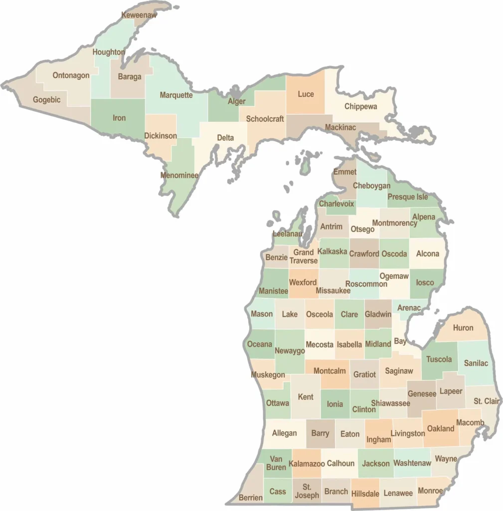
Imagine a map you can actually talk to. Well, almost. An interactive Michigan county map is a digital map where you can click on any county to learn more about it. Think of it like a smartphone app for geography. You tap on Grand Traverse County, and it shows you that the county seat is Traverse City, famous for its cherries.
Why is this so useful?
Plan a Trip You can click around to see which counties have the best beaches, like those in Muskegon County or Alpena County.
Find Your Way It helps you see how major highways like I-75 connect counties from Monroe County all the way up to Mackinac County.
Learn Cool Facts Discover that Marquette County is the largest by land area or that Lake County is almost entirely forest.
This tool turns a simple Michigan county map into a gateway for travel and tourism.
Michigan County Map
🎥 Watch Our Michigan Map SECRETS Revealed!
See How to Discover Hidden Gems in Under 2 Minutes! ⚡
🔥 What You’ll Discover: Hidden beaches, secret parks, local favorites,
and how to download your FREE printable PDF map instantly!
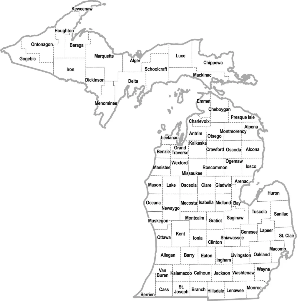
Michigan Simple County Map: Clean & Printable Outline
Sometimes you just need the basics. A simple Michigan county map is perfect for that. It shows the clear outlines of all 83 counties without any extra details. This is the map you want for printing or quick reference.
Imagine a clean black and white page. You can easily see each county’s shape. This makes it great for students or anyone planning a trip who needs a straightforward guide.
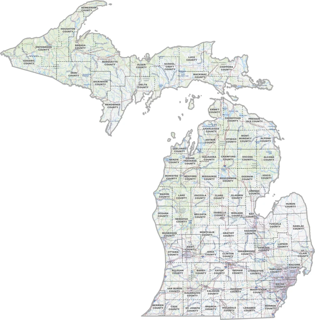
Michigan Topographic County Map: Terrain & Elevation Details
Want to see more than just lines? A topographic map of Michigan County adds the lay of the land. It shows hills, valleys, and elevation changes across Michigan’s counties.
This type of Michigan county map helps you understand the landscape. You can see why some counties have more forests or how the Great Lakes shape the borders. It’s like having a terrain model on paper.
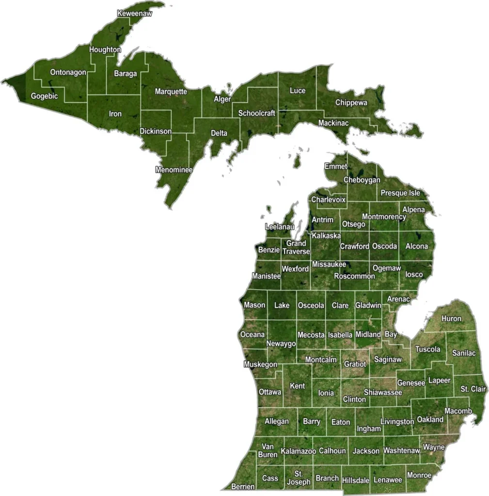
Michigan Satellite County Map: Real-View Imagery
For a real-world view, check out the Michigan county satellite map. This uses actual images from above to show Michigan’s counties as they really look. You get to see the natural colors and textures of the land.
Satellite views are amazing for spotting waterways, urban areas, and farmland within each county. It’s the closest thing to looking out an airplane window while still seeing all the county boundaries clearly.
These three map types each give you a different way to explore Michigan’s counties. Whether you need simplicity, terrain details, or real imagery, there’s a perfect Michigan county map for your needs.
Map of Michigan Counties and Capitals
This is where things can get a tiny bit tricky. Michigan has one state capital, which is the city of Lansing in Ingham County. However, each individual county has its own main city called a county seat. This is like each county having its own mini-capital where the local government buildings are located.
Michigan has 83 counties across the Lower and Upper Peninsulas. The tables below list every county and its county seat, the city where county government is based.
No matching county or county seat found.
Counties Alcona to Grand Traverse
County
County Seat
Alcona
Harrisville
Alger
Munising
Allegan
Allegan
Alpena
Alpena
Antrim
Bellaire
Arenac
Standish
Baraga
L’Anse
Barry
Hastings
Bay
Bay City
Benzie
Beulah
Berrien
St. Joseph
Branch
Coldwater
Calhoun
Marshall
Cass
Cassopolis
Charlevoix
Charlevoix
Cheboygan
Cheboygan
Chippewa
Sault Ste. Marie
Clare
Harrison
Clinton
St. Johns
Crawford
Grayling
Delta
Escanaba
Dickinson
Iron Mountain
Eaton
Charlotte
Emmet
Petoskey
Genesee
Flint
Gladwin
Gladwin
Gogebic
Bessemer
Grand Traverse
Traverse City
Counties Gratiot to Midland
County
County Seat
Gratiot
Ithaca
Hillsdale
Hillsdale
Houghton
Houghton
Huron
Bad Axe
Ingham
Mason
Ionia
Ionia
Iosco
Tawas City
Iron
Crystal Falls
Isabella
Mount Pleasant
Jackson
Jackson
Kalamazoo
Kalamazoo
Kalkaska
Kalkaska
Kent
Grand Rapids
Keweenaw
Eagle River
Lake
Baldwin
Lapeer
Lapeer
Leelanau
Leland
Lenawee
Adrian
Livingston
Howell
Luce
Newberry
Mackinac
St. Ignace
Macomb
Mount Clemens
Manistee
Manistee
Marquette
Marquette
Mason
Ludington
Mecosta
Big Rapids
Menominee
Menominee
Midland
Midland
Counties Missaukee to Wexford
County
County Seat
Missaukee
Lake City
Monroe
Monroe
Montcalm
Stanton
Montmorency
Atlanta
Muskegon
Muskegon
Newaygo
White Cloud
Oakland
Pontiac
Oceana
Hart
Ogemaw
West Branch
Ontonagon
Ontonagon
Osceola
Reed City
Oscoda
Mio
Otsego
Gaylord
Ottawa
Grand Haven
Presque Isle
Rogers City
Roscommon
Roscommon
Saginaw
Saginaw
St. Clair
Port Huron
St. Joseph
Centreville
Sanilac
Sandusky
Schoolcraft
Manistique
Shiawassee
Corunna
Tuscola
Caro
Van Buren
Paw Paw
Washtenaw
Ann Arbor
Wayne
Detroit
Wexford
Cadillac
Knowing the county seat helps you understand where the action is in each area. For example
Wayne County = Detroit
Kent County = Grand Rapids
Kalamazoo County = Kalamazoo
Genesee County = Flint
When you look at a Michigan county map, you are not just seeing shapes. You are seeing the homes of these important cities.
The Simple Way to Understand Michigan County Lines
So you have your interactive map open. It is fantastic for clicking around. But sometimes you just want to know how to map by county Michigan style for a specific reason. Maybe you are planning a family reunion and need to see all the counties in Michigan map view to find a central spot. Or perhaps you are a student trying to understand the map of counties in Michigan for a school project.
Do not worry. We have got you covered. Think of these different map views as different tools in your toolbox. Each one is perfect for a different job.
Maybe you are planning a family reunion and need to see all the counties in Michigan map view to find a central spot. Or perhaps you are a student trying to understand the map of counties in Michigan for a school project.
And if your exploration leads you to the scenic Lake Huron shoreline, our dedicated guide and detailed Alcona County Map Michigan will show you everything from Harrisville's lighthouse to the hidden gems within the Huron National Forest.
Michigan County Map Secrets Every Traveler Should Know
Sometimes you just need a clean, basic map. No fancy details, just the facts. This is the standard map of counties in Michigan. It shows you where one county ends and the next begins.
Think of it as your starting point. This kind of map is surprisingly useful for a few specific things.
Getting Oriented. It helps you quickly see how the state is organized and where a county is located.
Plotting a Drive. You can draw your route right on it to visualize your trip across different counties.
Learning the Basics. It's a clear, simple way to get familiar with the names and general shapes of Michigan's 83 counties.
It’s not the Michigan county map for finding a specific restaurant, but it’s the one you need to understand the lay of the land. Starting with this view makes every other, more detailed map easier to use.
How a Detailed County Map Makes Your Trip Better
Now, let us say you are planning a weekend getaway. You know you want to visit a city, but you also want to be near a lake or a park. This is where a michigan county map with cities becomes incredibly useful.
These maps add a new layer of information. You can see not just the county, but also the towns, major roads, and often parks and waterways inside it. For example, looking at a michigan county map with cities for Grand Traverse County instantly shows you that Traverse City is the main hub right on the bay. This helps you visualize your trip and see how everything connects.
Which Michigan County Map is Right for You? Find Out in 60 Seconds
Feeling unsure which one to use? Here is a simple guide.
For quick reference or printing: Use the simple outline map of counties in Michigan.
For trip planning or family history: Look for a Michigan county map with cities and roads.
For a fun, digital experience: Stick with the interactive Michigan county map to click and explore.
Printable Michigan County Map Outline
Sometimes, you just need a piece of paper. A printable Michigan county map is perfect for classrooms, road trips where you might lose cell service, or for a fun coloring project. You can find these maps in common file formats like PDF or PNG.
A simple Michigan county map in black and white is great for printing because it uses less ink. These high-resolution outline maps are clean and easy to read. Teachers love them for geography lessons. Want to trace the border of Ontonagon County? Go for it. A printable vector Michigan county map gives you that flexibility.
If your focus turns to Michigan's center for science and industry, our dedicated Midland County Map Michigan is an essential tool. It provides a clear view of the county's layout, from the headquarters of Dow to the vibrant downtown riverfront, perfect for both business and recreational planning.
A Detailed Look at Michigan's Two Peninsulas
Michigan's split personality is its defining feature. The two peninsulas are connected by the mighty Mackinac Bridge, and each has a very different feel.
Lower Peninsula Counties
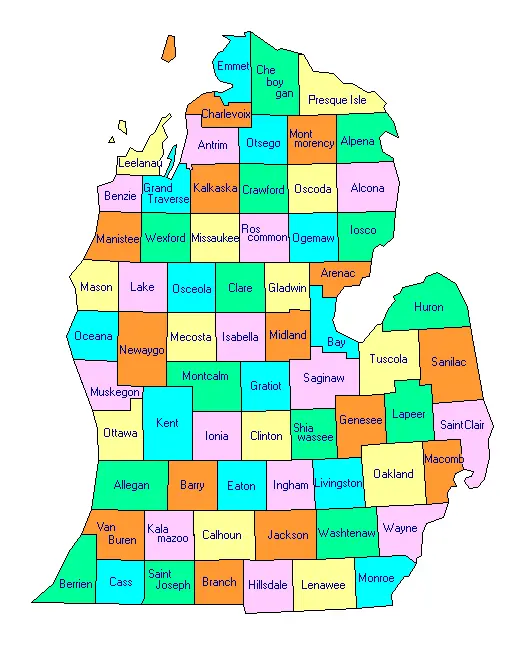
Lower Peninsula Counties Map
This is the "mitten." Most of Michigan's population lives here. The counties in the Lower Peninsula range from the urban centers of Wayne County and Oakland County to the famous beach towns in Berrien County and Van Buren County. This region is surrounded by Lake Michigan, Lake Huron, and Lake Erie. It is where you will find big cities, vast farmlands, and popular vacation spots.
Upper Peninsula Counties
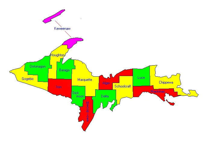
Upper Peninsula Counties Map
The Upper Peninsula, or "the U.P.," is a world of its own. It is known for its rugged beauty, dense forests, and proximity to Lake Superior. The counties here, like Gogebic County and Alger County, are often larger in area but have fewer people. This is the place for breathtaking waterfalls, historic lighthouses, and real solitude. Keweenaw County, the least populous, is a paradise for those seeking peace and quiet.
History of Michigan County Formation
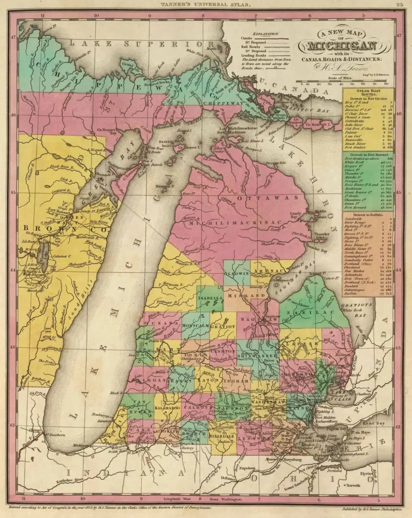
Michigan County Historical Map - 1836
Michigan did not always have 83 counties. When it was just a territory, the area was divided into a few large districts. As more settlers arrived, these large areas were split into smaller, more manageable counties. This process of formation happened throughout the 19th century.
Genealogy researchers know that these shifting boundaries are important. An ancestor might have lived in a area that was once part of one county but is now in another. Looking at a historical Michigan county map from the 1800s can solve these mysteries. The oldest counties, like Wayne County, were formed early on, while others were added later.
Using a Michigan County Map for Genealogy and Research
Speaking of family history, a Michigan county map is a powerful tool for genealogy. Why? Because many old records, like birth certificates and land deeds, are kept at the county level. If you are trying to find information about your great-grandparents who lived in Michigan, you first need to know which county they lived in.
Once you have the county name, you can contact the local county clerk's office or historical society. This makes your search a hundred times easier. Understanding county boundaries, both past and present, is a crucial first step in any research project about Michigan's people and places.
Frequently Asked Questions
Michigan has 83 counties in total. You can find all of them on our interactive Michigan county map.
Marquette County in the Upper Peninsula is the largest by land area.
Wayne County, which is home to Detroit, is the most populous county in Michigan.
We offer free, high-quality PDF maps of Michigan's counties. These printable maps are perfect for planning your travels, school projects, or simply learning more about the Great Lakes State.
Michigan State University is located in East Lansing. If you look at a map, you'll find East Lansing right in the heart of Ingham County.
Branch County is surprisingly easy to find! It's in the southern part of Michigan's Lower Peninsula, right along the border with the state of Indiana.
Conclusion
Michigan has 83 counties split between the Lower Peninsula (68) and the Upper Peninsula (15).
An interactive Michigan county map is a fantastic digital tool for planning and learning.
Each county has a county seat, which is its main administrative city, like Detroit in Wayne County.
Printable maps are useful for offline activities and educational projects.
Understanding county boundaries is very helpful for genealogy and historical research.
We hope this guide helps you see the Michigan county map in a whole new light. It is not just a map. It is a storybook of places waiting for you to explore. What county will you discover first?
Got a question about the Michigan County Map or something you’d like to tell us? We’re always happy to listen.